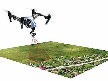
Aerial photogrammetry services have transformed the way we capture and analyze spatial data, offering precise measurements and detailed imagery that cater to a wide range of industries. Whether you’re in construction, urban planning, or environmental management, aerial photogrammetry services can deliver high-resolution, scalable data from the air. But what exactly is aerial photogrammetry, and why is it becoming indispensable?
Why Aerial Photogrammetry Services Matter
The advantages of aerial photogrammetry go beyond mere imagery. It offers high-resolution, geospatially accurate data that can be processed into valuable formats such as orthophotos, 3D models, and contour maps.
Benefits Of Traditional Surveying
Traditional surveying can be slow, labour-intensive, and costly. Aerial photogrammetry allows rapid data collection across large areas, reducing time and resource demands.
The Value of High-Resolution Imagery
High-resolution imagery is essential for detailed analysis. For example, in construction, precise images help in monitoring progress and managing site changes. With photogrammetry, you can achieve a level of detail that enhances planning, accuracy, and decision-making.
Types of Aerial Photogrammetry Services
There are several methods of aerial photogrammetry, each tailored for specific applications.
Vertical Photogrammetry
Vertical photogrammetry involves taking images straight down from an aircraft or drone. This method is used for creating orthophotos and maps.
Oblique Photogrammetry
Oblique photogrammetry captures images at an angle, providing a more natural perspective. This is especially useful for visual assessments in real estate or construction.
3D Aerial Photogrammetry
Using multiple images from various angles, 3D photogrammetry creates realistic models of landscapes, buildings, and even entire cities.
Applications of Aerial Photogrammetry
Aerial photogrammetry is widely applicable, making it a versatile tool across numerous sectors.
Urban Planning and Development
In urban planning, aerial photogrammetry provides data for zoning, infrastructure planning, and landscape analysis, giving planners a complete view of potential project impacts.
Environmental Monitoring
It’s ideal for tracking ecosystem changes, assessing environmental damage, and managing conservation efforts.
Agricultural Mapping
Farmers use aerial photogrammetry to monitor crop health, analyze soil types, and optimize planting strategies.
Mining and Quarrying
In mining, photogrammetry assists in site mapping, resource estimation, and safety monitoring.
Infrastructure and Utility Mapping
It’s also instrumental in the construction and maintenance of infrastructure like roads, railways, and pipelines.
How Aerial Photogrammetry Works
The process begins with capturing images from aircraft or drones, followed by complex image processing to create models and maps.
Equipment Involved
Photogrammetry requires specialized cameras, GPS, and LiDAR sensors to ensure accurate data collection.
The Role of Drones and Aircraft
Drones have become popular due to their flexibility, lower costs, and ability to capture high-resolution images in diverse terrains.
Image Processing and 3D Model Generation
Once captured, images are processed through photogrammetric software that uses algorithms to stitch them into cohesive maps or 3D models.
Benefits of Hiring Professional Aerial Photogrammetry Services
Professional photogrammetry services offer unmatched accuracy, cost efficiency, and expertise.
Accuracy and Detail
Expert teams ensure precise measurements critical in construction, land surveying, and environmental monitoring.
Cost Efficiency
Hiring a professional team often reduces overall costs by avoiding equipment expenses and rework due to errors.
Versatility Across Industries
Professional services are adaptable to different industries, whether you’re in agriculture, mining, or real estate.
Choosing the Right Aerial Photogrammetry Service Provider
Selecting the right provider is essential to the success of your project.
Factors to Consider
Look for experience, certification, and industry-specific knowledge in your provider.
Importance of Experience and Certification
Certified professionals are likelier to deliver reliable, high-quality data with minimal error.
Challenges and Limitations of Aerial Photogrammetry
While beneficial, aerial photogrammetry has limitations that clients should be aware of.
Weather and Environmental Factors
Weather conditions can affect flight stability and image clarity, impacting data quality.
Regulatory Challenges
Airspace regulations vary, requiring permits and permissions that can delay projects.
Data Processing Complexity
High-resolution image processing requires specialized software and expertise, which can be complex and time-intensive.
The Future of Aerial Photogrammetry
Advancements in technology are pushing the boundaries of what’s possible with aerial photogrammetry.
Innovations in Drone Technology
With better sensors and improved AI, drones capture more transparent, detailed images.
AI and Machine Learning in Image Processing
AI and machine learning are streamlining image analysis, speeding up workflows and improving accuracy.
Cost Considerations for Aerial Photogrammetry Services
Costs can vary depending on project size, data resolution, and equipment required.
DIY vs. Professional Aerial Photogrammetry
While some may consider DIY approaches, professionals offer greater accuracy and dependability.
When DIY is Feasible
For small, straightforward projects, DIY with a consumer drone might be feasible.
Why Professionals Are Often Preferred
Professionals bring a depth of experience and access to advanced equipment, which ensures high-quality results.
How to Prepare for an Aerial Photogrammetry Project
Proper preparation includes planning, permissions, and compliance with local regulations.
Pre-Flight Planning
Coordinate with your service provider to outline objectives and project requirements.
Site Permissions and Legal Compliance
Ensure that all required permits and legal compliances are in place.
Case Studies of Successful Aerial Photogrammetry Projects
Examples of how companies have used aerial photogrammetry to improve accuracy, reduce costs, and achieve more significant project insights.
Conclusion
Aerial photogrammetry services offer cutting-edge technology for accurate, large-scale data collection across various industries. With their high-resolution imaging, rapid data processing, and cost-efficiency, these services provide a transformative solution for modern surveying and mapping needs.


